

RealEarth

Mô tả của RealEarth
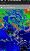
The RealEarth app provides access to real-time imagery and data products hosted by the University of Wisconsin - Madison Space Science and Engineering Center (SSEC). These products include global and regional remotely sensed atmospheric, terrestrial, and oceanographic imagery, observations of local meteorological parameters, and short-range predictions of future conditions. Features include:
- Select products to display by category, name, and time
- Pan and zoom map interface dynamically
- Display current location on map
- Animate by relative or absolute time steps
- Save custom favorites
Future enhancements will include capabilities for users to create custom geographic areas that will denote notification regions. Events such as severe weather, floods and fires will trigger a notification message directly to the user's mobile device.
Các ứng dụng RealEarth cung cấp truy cập vào hình ảnh và dữ liệu sản phẩm theo thời gian thực được tổ chức bởi Đại học Wisconsin - Madison Không gian Khoa học và Kỹ thuật Trung tâm (SSEC). Những sản phẩm này bao gồm toàn cầu và khu vực viễn thám trong khí quyển, mặt đất, và hình ảnh hải dương học, quan sát các thông số khí tượng địa phương, và dự đoán ngắn loạt các điều kiện trong tương lai. Tính năng bao gồm:
- Chọn sản phẩm để hiển thị theo thể loại, tên, và thời gian
- Pan và giao diện bản đồ zoom tự động
- Hiển thị vị trí hiện tại trên bản đồ
- Animate của bước thời gian tương đối hoặc tuyệt đối
- Lưu yêu thích tùy chỉnh
cải tiến trong tương lai sẽ bao gồm khả năng cho người dùng để tạo ra các khu vực tùy chỉnh địa lý mà sẽ biểu thị vùng thông báo. Những sự kiện như thời tiết khắc nghiệt, lũ lụt và cháy sẽ kích hoạt một tin nhắn thông báo trực tiếp đến điện thoại di động của người dùng.


